Volcanology - GHRU
|
|
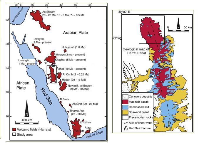
The Cenozoic volcanic fields, known locally as the Harrat, extend across the western regions of the Arabian Peninsula from Yemen in the south to the Levant in the north. These volcanic fields represent a surface manifestation of the rift-related magmatism, which began in the Early Oligocene, about 30 million years ago, with the formation of the Red Sea – Gulf of Aden – East African Rift System and led to the consequent breakup of Arabia from Africa.
The Harrat includes the early-formed Oligocene flood basalts of Yemen and the basaltic volcanic fields of AS Sirat, Al Birak, Nawasif – Al Buqum, Hadan, Kishb, Rahat, Khaybar, Lunayyir, Ithnayn, Hutaymah, Uwayrid, and Ash Shaam in Saudi Arabia. The latter extends northward from Saudi Arabia across Jordan to southern Syria.
|
| General Description of the Harrats of the Kingdom |
|
Khaybar-Ithnyan (Hutaym) – Al Kura
|
21,400
|
|
Rahat
|
18,100
|
|
Al Harrah (Ash Shama)
|
15,200
|
|
Nawasif – Al Buqum
|
10,800
|
|
Ar Rahah - Uwayrid
|
7,150
|
|
Al Kishb
|
6,700
|
|
Hadan
|
3,700
|
|
Al Birak
|
1,800
|
|
I’shara-Khirsat
|
<1,800
|
|
Lunayyir
|
1,750
|
|
Harairah
|
<1,530
|
|
Kurama (Hirmah)
|
1,100
|
|
Al Hutaymah
|
900
|
|
As Sirat
|
750
|
|
Jibal al Khatibah
|
320
|
|
|
|
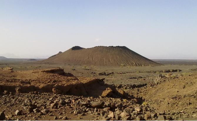
VORiSA project is primarily concerned with studying the northern part of the Cenozoic volcanic field of Harrat Rahat, known as Harrat Al-Madinah, which is believed to have witnessed the last historically recorded volcanic eruption in Arabia. In June 1256 AD (Jumada II, 654 A.H.), a volcanic eruption ensued a precursory series of shocks and produced 6 scoria cones and a 23 km long lava flow after 52 days of activity. The northwardly advancing lava flow came within 8 kilometers of the holy city of Al-Madinah. Located between latitudes 24° 10`N and 24° 27`N and longitudes 39° 33`E and 40° 03`E, Harrat Al-Madinah is mainly constructed of monogenetic, Strombolian-type basaltic volcanoes and lava flows that were extruded during the Quaternary (~1.7 Ma to 1256 A.D.) onto the Precambrian basement rocks of the Arabian Shield through NNW-trending en echelon vent zones. Basalts range in composition from olivine transitional basalt and alkali olivine basalt to hawaiite. More evolved rocks of mugearite, benmoreite, and trachyte occur mainly as domes and tuff cones as well as lava flows.
|
 |
|
The initial field trips to Harrat Al-Medina identified six probable locations for the research activity, they are 1. Al Malsa volcano; 2. Zargat Abu Zaid volcano; 3. Mosawdah volcano; 4. Southern volcano (gas pipeline volcano); 5. Fissure-fed lava flows and 6. The 1256 AD Medina volcano. The work was focused on mapping and detailed sampling of the products of each centre and its associated flows, in order better understand the range in eruptive styles and scenarios during this youngest phase of volcanism in the Harrat. In total, 225 outcrops were visited and most of them were sampled for future geochemical work
|
|
Eruption
|
Estimated Age
|
No. of Samples Collected
|
Sampled for Cosmogenic Dating
|
|
1. Al Malsa
|
~0.9 - ~1.2 Ma
|
25
|
Yes
|
|
2. Zargat Abu Zaid
|
~0.6 Ma – 4500 BP
|
25
|
Yes
|
|
3. Mosawdah
|
~0.6 Ma – 4500 BP
|
24
|
No
|
|
4. Southern Volcano
|
<4500-~1500 BP
|
21
|
No
|
|
5. Fissure-fed lava
Flows
|
<4500-~1500 BP
|
36
|
Yes
|
|
6. 1256 AD Madinah
|
Historical
|
81
|
Yes
|
|
|
Sampling for cosmogenic dating
Cosmogenic dating can be used to determine exposure ages of young subaerial basaltic lava flows that are otherwise difficult to date by more traditional methods such as K-Ar or 40Ar/39Ar dating. The method involves measuring cosmogenic 3He and 21Ne nuclides in olivines or pyroxenes. Eight lava samples were collected for this analysis In the field, care was taken to only sample the surface of each lava flow, and details such as elevation and bearing of surrounding hills. In the laboratory, each sample was crushed, sieved and cleaned, and then olivines picked by hand. This mineral separation was carried out in KAU laboratories between 20 April and 3 May. More than 1 g of olivine separate was obtained for 6 samples; only 0.4 was obtained for the remaining two samples. These samples will be analysed at the German Research Centre for Geosciences in Potsdam, Germany (GFZ-Potsdam).
|
|
AD1256 Tephra mapping
The tephra blanket surrounding the chain of eruptive vents of the AD1256 eruption is extensive and spreads both east and west of the chain. It is clearly visible on satellite images of the area. This distribution either indicates a lack of winds during the eruption, or more likely that several separate eruption columns were produced during the 52-day event (c.f. Camp and Roobol, 1987), each depositing tephra according to variable wind directions. In addition, the landforms clearly show that at least three major vents produced tephra fall, represented by the three highest cones. The summit geomorphology of these cones indicate the wind directions during the latest stage of the eruptions, and the relative chronology of their eruptions can also be determined from the near vent stratigraphy, which is still being collated from the field descriptions.
|
|
The strategy for mapping this deposit was to carry out a series of traverses, primarily on foot and covering the entire deposition area with a semi-regular network of points a few hundred metres apart. Sampling in a strict grid-pattern was avoided in order not to bias computational techniques that would be later used for evaluating the deposit geometry and volume. This tephra deposit is generally extremely well preserved and a carefully collected sample set is potentially a world-class example of a complex multi-stage basaltic eruption
|
|
Last Update
5/22/2013 11:30:51 AM
|
|